")
Raising temperatures in the Alps leads to more frequent and intense climatic extreme events that put ecosystems, natural resources and human activities at risk.
Streams and groundwater are threatened. Change in water availability (including snow) is already being observed, while habitats for fauna and flora are shrinking. At the same time, increasing threats among our ecosystems changed the way we live in the mountain environment.
Over the past decades, the Alpine space registered an increase of about +2C°, above the global scale average. This shift and relentless increase can be visualized in the climate stripes developed for our pilot sites, where data from 1985 till 2024 have been registered and translated into graphics.
What about the last 4 years? As 2025 was pronounced the hottest year ever registered, the trend is continuing unchanged.
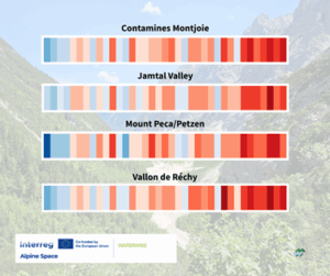
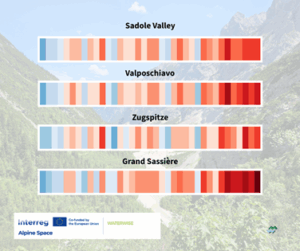
Each pilot site is unique, with its own context and set of environmental data. Recognizing these local specificities is essential to orient the development of ecosystem-based solutions for the management of water resources anchored to the local Alpine territories.
Only by integrating local knowledge, strengthening long-term water-resource monitoring, and fostering dialogue between science and policy can we design long-term, sustainable solutions to the challenges posed by climate change.
Sources
- Schimanke S., Ridal M., Le Moigne P., Berggren L., Undén P., Randriamampianina R., Andrea U., Bazile E., Bertelsen A., Brousseau P., Dahlgren P., Edvinsson L., El Said A., Glinton M., Hopsch S., Isaksson L., Mladek R., Olsson E., Verrelle A., Wang Z.Q., (2021): CERRA sub-daily regional reanalysis data for Europe on single levels from 1984 to present. Copernicus Climate Change Service (C3S) Climate Data Store (CDS), DOI: 10.24381/cds.622a565a (Accessed on DD-MMM-YYYY)
- https://cds.climate.copernicus.eu/datasets/reanalysis-cerra-single-levels?tab=documentation
- CERRA sub-daily regional reanalysis data for Europe on single levels from 1984 to present
- The Copernicus European Regional ReAnalysis (CERRA) datasets provide spatially and temporally consistent historical reconstructions of meteorological variables in the atmosphere and at the surface. The webpage was accessed on 28/01/2026