")
In the snow tourism sector, climate change effects, along with social and demographic changes, can lead to a potential decrease in the attractiveness of snow tourism destinations (STDs), and a consequential weakening of their local economies. However, adaptation solutions such as the inclusion of ecosystem services can serve as significant tools to mitigate potential impacts and thus reduce the vulnerability of STDs. Therefore, to identify the best solutions, it becomes essential to start from the analysis of the local context and assessment of the vulnerability of these destinations.
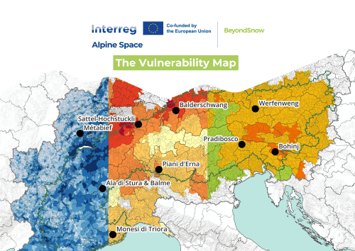
Vulnerability analysis
The exploration of the vulnerability of STDs required a meticulous analysis specifically adapted to the unique challenges inherent to alpine regions. Therefore, the Vulnerability Map, developed within the project, provides an initial assessment of the vulnerability of small Snow Tourism Destinations (STDs) in the Alpine Space, which are currently or will be affected in the future by climate change. It represents an application of the IPCC definition, based on the fundamental components of vulnerability such as exposure, sensitivity, potential impact, and adaptive capacity. It provides a comprehensive overview that integrates together biophysical, socio-ecological and economic dimensions.
The map is based on the development of an aggregated (synthetic) indicator of the vulnerability level of STDs to a particular impact of climate change, the decrease in snow cover. This Vulnerability Index is a composite indicator constructed through the synthesis of 12 different indicators related to the dimensions of vulnerability considered most relevant for understanding and increasing awareness of the impacts, expressing the various aspects of a multidimensional phenomenon through a single value. The number of useful indicators proposed by the project is much broader (for more information, see D.1.2.1 “Conceptual Document on the Vulnerability and Resilience of Alpine Snow Tourism Destinations”), but the project chose to rely on currently available data, and the choice fell on a composite indicator because it simplifies the analysis of socio-economic phenomena over time and across territories through synthesis.
The document detailing the individual indicators used, the processing procedure, and all the details related to the vulnerability map can be consulted at the following link: https://www.alpine-space.eu/wp-content/uploads/2024/03/BeyondSnow-Vulnerability-Map-deliverable-1.1.2.pdf.
A collaborative effort
Thanks to the efforts of the project’s Lead Partner, the Institute for Regional Development of Eurac Research, we have now reached an important milestone: the Vulnerability Map of Alpine Snow Tourism Destinations is now freely available online in a web GIS: https://maps.eurac.edu/catalogue/#/map/1667.
The map has been updated from the version included in the deliverable D.1.1.2 and uploaded online following the weighting of indicators, which was done in collaboration with project partners and observers. This collaborative effort ensured that the map reflects the most accurate and comprehensive assessment of vulnerability, making it a valuable resource for stakeholders. Collaborative weighting is crucial because it incorporates diverse perspectives and expertise, leading to a more balanced and representative evaluation of vulnerability. By involving multiple stakeholders in the weighting process, the project ensured that the indicators used are relevant and accurately reflect the local context and specific challenges faced by alpine regions. This approach enhances the credibility and usability of the map, making it a more effective tool for decision-making and planning.
Availability on data portal
In addition, the map and datasets are also available on the official European data portal, DATA.EUROPA.EU. This portal serves as a central access point for European open data, integrating information from international, EU, national, regional, local and geospatial data portals.
The map and data will also be integrated soon into the Atlas of the Alpine Convention, https://www.atlas.alpconv.org, part of the Alpine Convention’s System for Observation and Information on the Alps (SOIA), as a support for policy development and implementation of existing priorities set out in the Alpine Convention and its protocols.
If you need any further information, please contact beyondsnow@eurac.it.